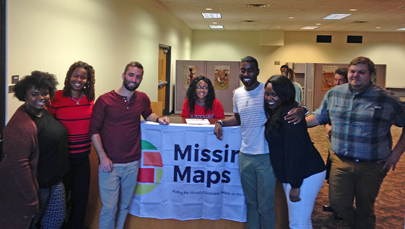
In recognition of World AIDS Day and Geography Awareness Week, students from the University of Georgia hosted a two-day Mapathon Marathon in November aimed at using spacial technologies to improve global public health.
The Public Health Association at UGA, an organization for graduate students in the UGA College of Public Health, partnered with the American Society for Photogrammetry and Remote Sensing Student Chapter (ASPRS) at UGA to organize the event Nov. 15 at UGA’s Main Library and Nov. 16 on UGA’s Health Sciences Campus.
Both events aimed to meet the mapping needs of the U.S. President’s Emergency Plan for AIDS Relief (PEPFAR). Kenya was assigned by the U.S. Department of State as the UGA team’s priority country for mapping. Roads and buildings mapped by the volunteers will assist international partners in HIV prevention initiatives.
Donating both their time and their laptops, participants traced roads and buildings using satellite imagery into OpenStreetMap, a free, editable map of the whole world built and maintained by volunteers and released with an open-content license.
“We organized the Mapathon because we thought it would be a good way to apply skills we’ve learned in class for a humanitarian effort. We used OpenStreetMap because we believe in their mission of creating free geospatial data to aid those in need,” said Andrew Knight, a graduate student in geography, ASPRS member and co-organizer of the event.
OpenStreetMap is supported by Missing Maps, a humanitarian project that preemptively maps parts of the world that are vulnerable to natural disasters, conflicts, and disease epidemics. Founded in November 2014 by the American Red Cross, British Red Cross, Humanitarian OpenStreetMap Team, and Médecins Sans Frontières/Doctors Without Borders, the organization has mapped countries such as South Sudan, the Democratic Republic of the Congo, and the Central African Republic.
Over the two-day period, UGA student, faculty and staff volunteers provided a total of 1,593 map edits that added 1,252 buildings and 271 kilometers of roads located in Kenya’s Bondo District.
“Our event was the only one in the entire state, which is impressive,” said Nolana Woolfork, a DrPH student in the College of Public Health and co-organizer of the event. “Young people can play an important role as data champions to help spread data-driven messages about HIV/AIDS to their peers and in their communities.”
Woolfork currently serves as a Virtual Student Foreign Service eIntern in the State Department’s Office of the U.S. Global AIDS Coordinator and Health Diplomacy, which leads PEPFAR’s implementation.
Dustyn Palmer, a systems analyst in the Center for Global Health Division of Global HIV/TB at the Centers for Disease Control and Prevention, traveled from Atlanta to provide mapping training for UGA students participating event.
“Understanding where communities are located, especially rural and high-risk communities, and how they are connected is essential to understanding whether HIV/AIDS services are in the right places and reaching the right people,” Palmer said. “Achieving an AIDS-free generation means that no one gets left behind – including people who are literally ‘off the map.’”
– Rebecca Ayer
Posted November 17, 2017.