Researchers at the University of Georgia have created a series of maps intended to help local health officials and policymakers make decisions about next steps in their response to COVID-19.
The team from the Economic Evaluation Research Group (EERG) at UGA’s College of Public Health analyzed a range of county-level data to help stakeholders visualize COVID-19 hotspots and understand how these communities compare to state and national averages.
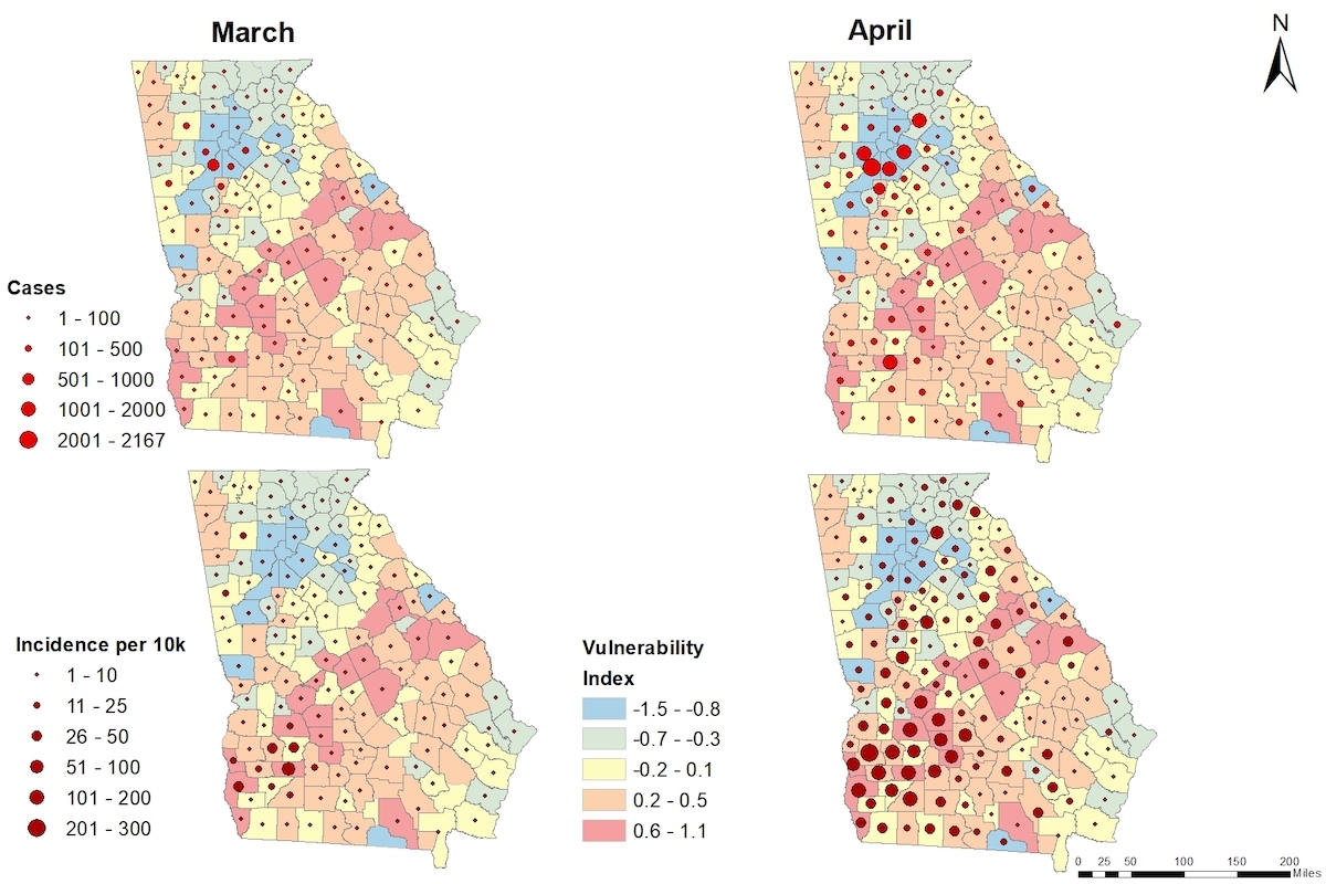
In addition, the team mapped counties based on population characteristics such as age, income, heart disease risk, and prevalence of heart disease in order to show how local outbreaks overlap with existing disparities, including health disparities, that make them more vulnerable to COVID-19 infections.
“The caseload is highest in specific counties that are also vulnerable. We would expect places with higher population density should see more cases, but this is not the case,” said project lead and EERG director Janani Thapa.
In fact, based on the number of cases and county vulnerability, Dougherty County was the hardest hit. And, when county population is accounted for, it’s clear that other counties in South Georgia are in the same boat.
This could be due to the fact that people with health conditions like cardiovascular disease and its associated risk factors like obesity and diabetes are at a higher risk for infection, and Georgia’s rural counties are disproportionately burdened by these diseases and risk factors.
“This disparity is evident in South Georgia. With this work, we want to emphasize that some counties are more vulnerable than others based on the identified risk for acquiring the virus that causes COVID-19,” said Thapa.
Thapa and her team hope this information can help local governments as they make plans to reopen businesses and maintain safety. Her team is currently working on identifying vulnerable counties based on health care resources available to handle case surge
“For the state, opening up businesses is essential to keep the economy running. However, there are strict public health practices we can follow to lower transmission and mitigate new infections,” said Thapa.For example, counties showing a high number of older residents or high rates of cardiovascular disease, should emphasize the need to continue practicing social distancing because their community is more vulnerable to contracting the virus.
The maps can also help inform where to allocate limited resources.
“The hard-hit counties will need more support than a neighboring county where the disease has not spread, not just for the health of their county but for the health of the adjoining county and the state. Healthcare is a social good,” said Thapa.
The team has released two maps that reflect March and April data. These and other maps to come are available at https://eerg.publichealth.uga.edu/.
The project team includes Stacy Zhang, Zhuo Chen, Lan Mu, Gang Li, and a committed group of graduate students – Kiran Thapa, Jue Yang, and Heejung Son. This project was supported in part by the UGA Presidential Interdisciplinary Seed Grant.
– Lauren Baggett
Read the story on UGA Today. Additional coverage at AJC, CBS 46, WABE 90.1 FM, Yahoo News, 11 Alive, Georgia Patch, WSB TV and WGAU Radio (#1 #2).
Posted on May 8, 2020.